Little Ocmulgee State Park, GA

These next few blog posts will be dedicated to a class I am currently taking at Georgia State University concerning the natural environments of Georgia.  

We visited Little Ocmulgee State Park on November 4, 2016 to observe the ecology of the Georgia Coastal Plain. Conditions were very dry as Georgia has been experiencing an exceptional drought. The trails through Little Ocmulgee state park are an excellent example of Sandhill and River Dune Upland Forest community, which are ultra-xeric woodland communities found within deep sandy knolls and ridges within the Coastal Plain. Little Ocmulgee state park contains Little Ocmulgee Lake which was built from the Little Ocmulgee River during the Great Depression by the Army Corp of Engineers.  This harsh sand covered environment is dominated by course sand cover, with an open canopy of Longleaf pines and an sub canopy dominated by Turkey oak. Other plant species include the Bluejack oak (Quercus incana), Sand post oak, poison oak, sparkleberry, southern sand-grass, and Gopher apple. The endangered and endemic gopher tortoise is a key stone species that can be found here, and we spotted at least one burrow.  We also spotted a beautiful southern hognose snake which I respectfully let slither away without a photograph. 
Prescribed fire is a necessary component to keeping this community healthy and without it, hardwoods may take the place of fire adapted trees such as the Longleaf pine. While hiking here we witnessed all three growth stages of the Longleaf pine (Pinus Palustris).
Turkey oak (Quercus laevis), Reindeer lichen (Cladonia) and Haircap moss (Polytrichum commune). Named after the fact that someone thought it's leaves are reminiscent of a turkey's foot, the Turkey Oak is one of the scrub-oak species that is often found alongside Longleaf pines.
Bald cypress, (Taxodium distichum) in all of its fall red pigmented glory.
Romantically named cypress knees, these modified roots, or pneumatophores, are created by various species in the the Taxodioideae family.  Although their exact function is not known, they are believed to both help the tree exchange gases in anorexic environments (low oxygen) and stabilize the roots in muddy conditions such as the swampy areas they are commonly found in.
Arborglyph, boardwalk trail at Little Ocmulgee State Park.
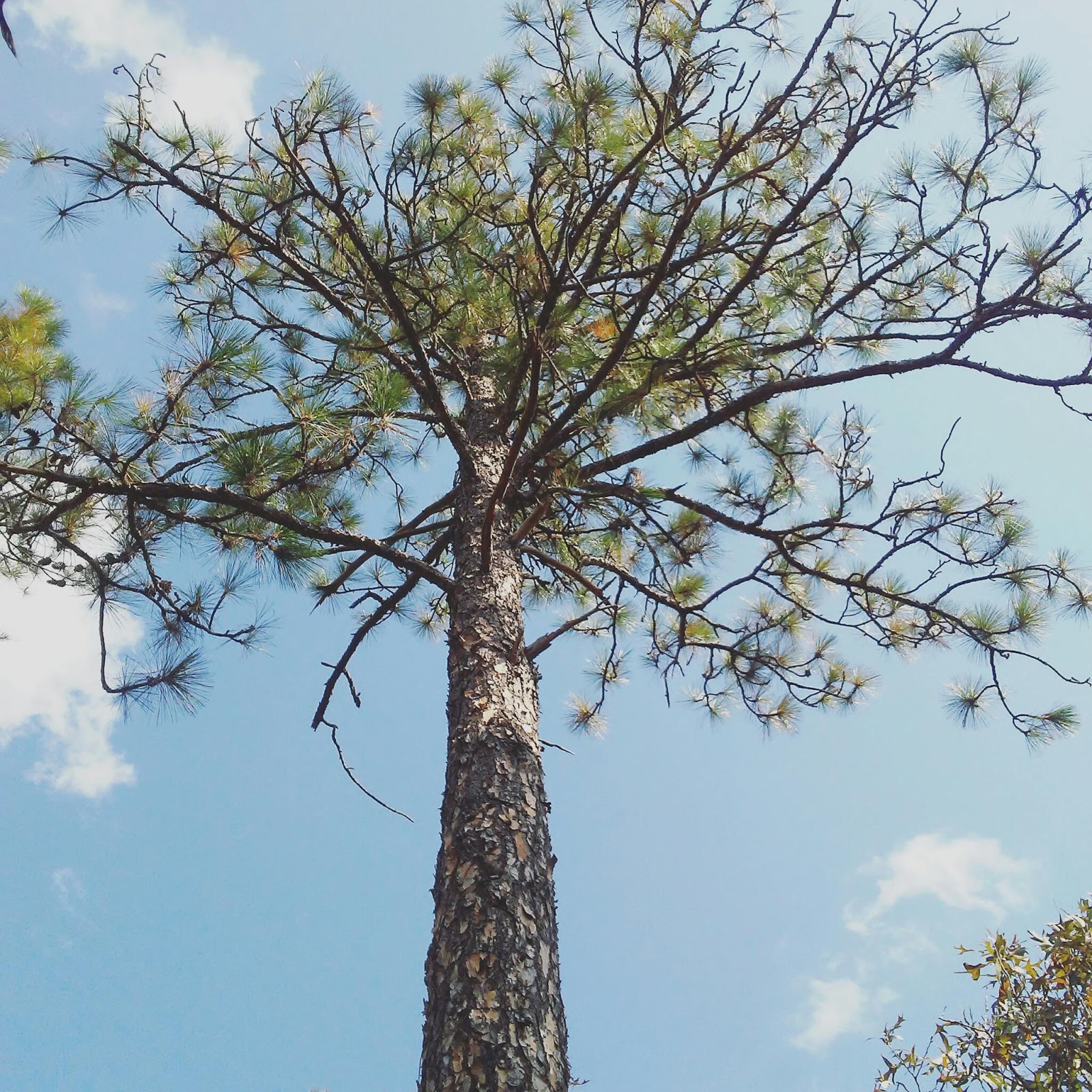
The Longleaf pine (seen above) has the greatest longevity of any other pine species growing in the South, surviving 300 to 500 years. It has evolved in an environment of fire and has consequently developed a fascinating strategy to survive in such a climate, with 3 distinct stages of growth.
After germination the tree begins in the initial grass stage, where the tuffs of the needles resemble a shrub of grass. The tree then steadily stores carbon within it's roots and continues root growth underground. In the grass stage a low-intensity fire such as one mimicked during a prescribed burn does not harm the plant as it is protected by long tufts of needles. A long leaf can stay in this stage for 3 to 25 years, amazingly assuring the best possible chance of survival at all odds. 
Once the seedlings emerge from grass stage they quickly bolt into what is called rocket stage, using the carbon carefully stored within the roots for a rapid growth of 4 to 5 feet in a single growing season. After this rapid growth and from about the height of at least three feet tall they are in sapling stage, where they are once again most likely to withstand the flames of a forest fire,  Perhaps this is why they do it so quickly.
pictured above is a Longleaf pine seen in both grass and rocket stage
This beautiful and fragrant Eastern red cedar, (Juniperus virginiana) is an example of a species that can thrive in this type of community only if fire suppression has not been utilized. Without fire, these trees might soon out-compete those adapted to fire, such as the scrub oaks and pines.
Usnea strigosa lichen ,
growing on a branch of a small Turkey oak tree. Lichens are a true wonderment of nature, and I am still grasping how to understand them. "A lichen is a symbiosis. That means that it is two or more organisms living together such that both are more successful within the partnership than they would have been if they were living on their own.All lichens are made up of a fungal partner and either/or an algal partner or a cyanobacterium partner, or both". As of late we are also learning that lichens are very sensitive to air pollution and may be able to serve as a bioindicator of air quality. 

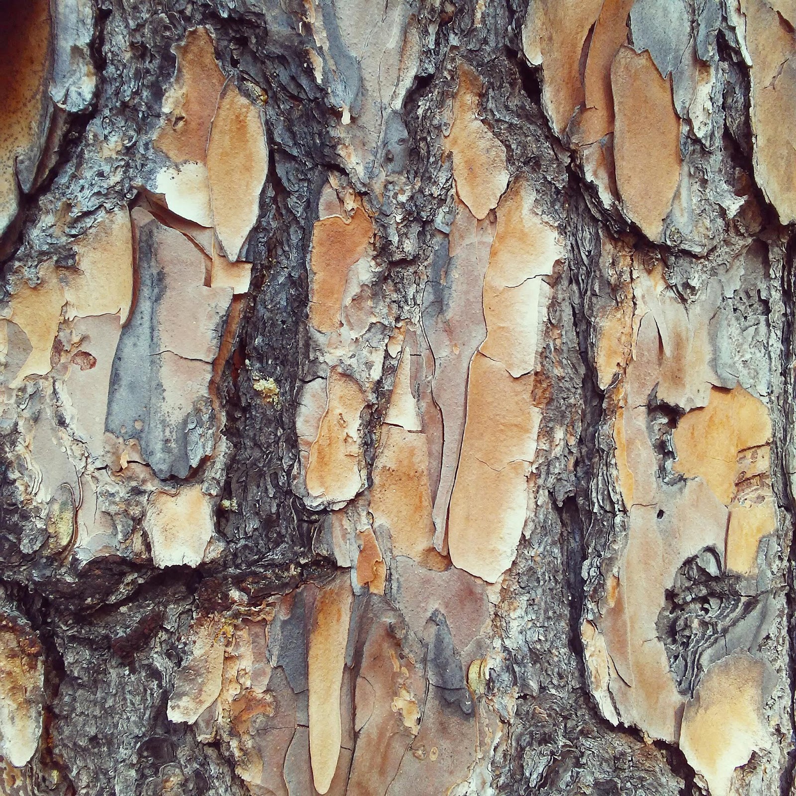
The fast growing Slash pine (Pinus elliottii) as pictured above and below, was planted in place of Longleafs for timber once all the old-growth Longleafs were deforested in Georgia.  It is native to South Georgia and Florida.  On a personal note, my great- grandfather was once among the many field workers who tapped Longleaf pines for the turpentine industry and remembers when the Slash pine was being hailed as superior to the slower growing Longleaf.
Sand Post Oak (Quercus margaretta)
this lichen is unknown to me. if anyone has an idea of what it may be please comment below!

Wormsloe Historic site and the Georgia coastal marsh, Savannah, Georgia

These next few blog posts will be dedicated to a class I am currently taking at Georgia State University concerning the natural environments of Georgia. 

We visited the managed forest preserve, Wormsloe Historic Site and Tybee Island in Savannah, Georgia on the weekend of November 4, 2016 to experience a taste of Georgia's Maritime Ecoregion.  The Maritime Ecoregion of Georgia is a small but incredibly vital one, containing the largest area of the protected maritime forest of any state on the East Coast,  as well as one-third of the remaining salt marsh habitat on the entire East-Coast.  This is largely due to the protection of Georgia's barrier islands thru Federal, State, and private ownership.
The distribution of Maritime forest along the coast is often interrupted by bays and inlets, or by narrower barrier islands that are not large enough to support forest growth. Although protections are under place, urban development continues to encroach upon these communities at a much higher rate than ever before as land that once was considered inhabitable or of little value is converted into golf courses and luxury resorts. It also becomes much more difficult to prescribe fire to forests who benefit from the use of fire management in places where roads intersect and housing is near by. 

The Maritime Ecoregion is also characterized by Salt Marshes and Brackish Tidal Marshes, Maritime Dunes, Interdunal Wetlands, Tidal Swamps, Intertidal Beaches and Sand Bars and Mud Flats, and Freshwater Tidal Marshes.
The Wormsloe Historic Site and property is and managed by the Georgia Department of Natural Resources and is open to the public as a state park. It is located on the southern end of the Isle of Hope and is bordered by Jones Creek and Jones Marsh on the East and Moon River and surrounding marsh to the West. Approximately 60% of the Isle of Marsh has been preserved in it's natural state, which includes Maritime Forest, Intertidal Marsh, and limited Freshwater Wetland habitat. 
Recent trends of sea level rise are documented at 3 to 6 mm per year. (https://tidesandcurrents.noaa.gov/sltrends/slrmap.htm)
The island core is currently 3 to 5 meters above mean sea level.  Early 19th century records indicate that the hydraulic heads of artisan wells located on the property were once well above the surface, although they are now 40 feet below earth surface. 
At least one well on the property showed evidence of saltwater intrusion on 11/6/2016.

On the Beach of Tybee Island we observed an example of the Maritime dune system. The texture of the beach sand is much more thick and muddy than one might expect of a natural beach, due to the course sands being dredged from the ocean floor to widen shipping lanes for cargo ships headed to the port of Savannah. You can read a little more about the $706 million project here.
We observed the ecology of the dune formation with several species of flower still in bloom. Plants of Maritime dunes may include some trees that are salt tolerate such as the Southern Red cedar and Live oak, but are mostly characterized by small shrubs and vining plants that helps to hold the sands together.  We observed pennywort, Beach morning-glory, Dune hairgrass, Dune prickly-pear, Wax-myrtle, Peppervine, Saw palmetto, and Railroad vine.  Other common plants of this ecosystem include Spanish dagger, Creeping frogfruit, and Groundsel tree. 
These dunes are a critical nesting habitat for five of the seven known species of endangered sea turtles, with the majority of nests belonging to loggerheads and leatherbacks.


Southern Red Cedar (Juniperus virginiana  var) covered with Spanish Moss (Tillandsia usneoides) at Jones Marsh Creek along the public trail of Wormsloe Historic Site.  Spanish moss is a native, perennial, epiphyte herb which is in fact neither a moss or lichen,  It is a flowing plant, which anchors onto a host plant without taking any water or nutrients from the host.   It derives water from humidity and rainfall, and nutrients from the air.  Often also called an air-plant or old-man's beard, it was once commonly used by native Americans to weave bedding, rugs, and rope. I have also heard it referred to as witch's hair. Spanish moss is common throughout the Deep South.

This, to me, is what home looks like.  A Magnolia grandifora, Southern Live oak (Quercus virginiana, and Spanish moss trio.

 Magnolia grandiflora in bloom during the summer a little south of Wormsloe Historic Site at Jekyll Island. Magnolia's bloom throughout the summer, so none were in bloom during this November visit.

skink spotted on the maritime forest floor.

Fiddler crab hiding in a deer print. 
The southern portion of Jones Marsh, where these sands lie, has been impacted by the large-scale dredging of soils moved to construct the Diamond Causeway (1968-1972). 
Saw palmetto is a groundcover found in Maritime forests and most closely associated with Longleaf pine forests. It's medicinal uses that have been known to native Americans for centuries are currently being explored, and Saw palmetto supplements can be bought in capsule form at your local grocer as a treatment for many ailments, most notably enlarged prostate in men and hormonal imbalances in women.
an unknown fungus or lichen with a pretty pastel hue
Beach morning-glory (Ipomoea imperati) found on the Maritime dune of Tybee Island.
Sunset over Jones Marsh from Wormsloe 
Jones Marsh and Jones Creek at Wormsloe Historic Site
Ghost shrimp found in its hole on the forebeach of Tybee Island. (as soon as this picture was taken we sent it back home)

This lichen is my absolute favorite species. It is called Cryptothecia rubrocincta, or more commonly Christmas wreath lichen. Growing up I always heard it referred to as bubble gum lichen and that's what I still like to call it.
Hericium erinaceus, 
also known as Lion's mane mushroom or bearded tooth mushroom, is often found growing on hardwoods and is both edible and medicinal and is widely consumed in Asia where is it also native. (There are some look a-likes, though, so please do not ingest any wild mushrooms unless you have done more research than just my blog post ;)
Atlantic ghost crab on a primary dune.
Saw palmetto block print I carved in 2013
Live oak (Quercus virginiana) a true stand-out species of the Maritime forest, with leaves that stay green all year.
Maritime forest seen along Jones Marsh. To the right, Sabal palmetto,( or cabbage palmetto) and to the left, Cedar.

Cloudland Canyon

               These next few blog posts will be dedicated to a class I am currently taking at Georgia State University concerning the natural environments of Georgia. 

600 million years ago the area of Coudland Canyon was once covered by a shallow sea full of tiny marine organisms, some of whose remains would be pressed into the limestone bedrock and are still visible today within the exposed rock at sites like Ruby Falls within the Mountain.  Cloudland Canyon lies on the Southern end of Lookout Mountain, which was formed over 250 million years ago during the collision of North American and Africa along with the formation of the Appalachian Mountain range. This collision bent and folded the existing layers of rock, creating cracks that allowed water through to begin the process or erosion that would eventually create the surrounding lower elevation areas such as Cloudland Canyon. So essentially, Cloudland Canyon was formed from erosion, and long ago the surrounding elevation was all much higher.  The Appalachian Mountains used to be a mighty tall range that is still slowing eroding into the sea.  What we see at Cloudland Canyon is the product of that erosion and a forest that was once under the sea, and if current trends of sea level rise continue, it may once again be.

Several ecological communities can be found here, such as Oak-Pine-Hickory forest and pine-oak woodlands.
The Acidic Oak-Pine-Hickory forest community seen here includes tree species such as Southern red oak (Quercus falcata), White oak (Quercus alba), Rock Chestnut oak (Quercus montana), Post oak (Quercus stellata), Scarlet oak (Quercus coccinea), Shortleaf pine (Pinus echinata), Virginia pine (Pinus virginiana), sourwood (Oxydenfrum arboreum), and flowering dogwood (Cornus florida).

The sandy, acidic soils created by sandstone and shale bedrock support acid loving ericaceous shrubs such as mountain laurel (Kalmia latifolia), hillside blueberry (Vaccinium pallidum), sparkle berry (Vaccinium arboreum), fringe-tree (Chionanthus virginicus), and witch-hazel (Hamamelis virginiana) .

The park is also home to Acidic Cliff and Rock Outcrop communities, which support mountain spleenwort (Asplenium montanum), partridge-berry (Mitchella repens), and hairy-southern bush-honeysuckle, which makes me laugh and just to name a few.

"Located on the western edge of Lookout Mountain, Cloudland Canyon is one of the largest and most scenic parks in the state. Home to thousand-foot deep canyons, sandstone cliffs, wild caves, waterfalls, cascading creeks, dense woodland and abundant wildlife, the park offers ample outdoor recreation opportunities. Hiking and mountain biking trails abound. The most popular hiking paths include the short Overlook Trail, strenuous Waterfalls Trail and moderate West Rim Loop Trail. Mountain biking is available at the newly developed Five Points Recreation Area and along the Cloudland Connector Trail. The park also includes an 18-hole disc golf course, wild caves available for touring during select months of the year, a fishing pond, trails for horseback riding, picnicking grounds and numerous interpretive programs, especially on weekends. Guests seeking an overnight experience can choose from fully-equipped and comfortable cottages, quirky yurts or several different types of camping and backpacking options. Come enjoy the great outdoors at Cloudland Canyon State Park."
http://www.gastateparks.org/CloudlandCanyon

On this day of early Fall October 15, 2016, North Georgia has been experiencing a severe drought and none of the waterfalls or spray cliffs in the park had water flow. Signs of drought could also be seen in many of the wilting ericaceous plants.
Virginia pine (Pinus virginia)
wild blueberries (Vaccinium arboreum

dry shrubs and rock outcroppings

Christmas fern (Polystichum acrostichoides)
Drought conditions have severely wilted this rhododendron, which likes a moist and acidic environment.

Calcareous cliff rocks in Cloudland Canyon are high in Calcium and limestone and are easily eroded.

 Rhododendron maximum
( this is a photo of Rosebay rhododendron seen in bloom on an earlier trip to the canyon in mid-summer)
Kalmia latifolia
(Mountain laurel, also seen earlier in the year when it was in bloom early summer)
turkey tails (Trametes versicolor) are a common polypore mushroom found in many parts of the world and has been used medicinally in many cultures as well.
Sassafras sapling (Sassafras albidum), a fragrant tree made locally famous for it's use in brewing root beer
Wild Hydrangea (Hydrangea arborescens)
Autumn leaf butterfly competing with paper wasps for the sap of this tree.
the bright beginnings of the unmistakable and edible Chicken of the Woods fungus, also known as sulphur shelf , (Laetiporous sulphureus)
The white spots seen on this young Hemlock tree are a colony of the Hemlock Woolly Adelgid (HMA), which is an invasive insect imported from Asia that has decimated Georgia's Hemlock populations and continues to spread quickly across the state. 

scenic views from the rim trail show the exposed bedrock cliffs 

Davidson-Arabia Mountain Nature Preserve


These next few blog posts will be dedicated to a class I am currently taking at Georgia State University concerning the natural environments of Georgia. 

Granite outcrop communities have been said to be the crown-jewel of Georgia natural communities because they feature a rare suite of endemic or nearly endemic species, and Georgia has more of these outcrops than any other state. (L.Edwards,The Natural Communities of Gerogia p.303) Mount Arabia is a perfect example of one of these communities, consisting of granitoid rocks known as Lithonia gneiss which is a nomenclature distinct to Mount Arabia.  It is with much awe that I also mention that although Arabia Mountain, Panola Mountain, and Stone Mountain are all granite outcroppings within 20 miles of one another they each are composed of a distinctly different composition of granitoid rock. Mount Arabia is a perfect example of the healthy successional plant community that is adapted to all three of these just mentioned.  The many stages of succession can be observed here, starting from Xanthos and Endolithic lichens and Elf Orpine, and moving all the way up to Virginia Pine trees and Muscadine Vines. Many of these plants are endemic and/or federally endangered, so be careful where you step! If you plan on exploring the mountain in the summer please be aware of ticks, which are abundant here! This is a truly special place that we are lucky to have so close to the city and still largely intact.  
Find out more about the trails and history here:  arabiaalliance.org

Here are some of our field findings from Mount Arabia on September 16th, 2016:
(Photos taken from trails located in Davidson-Arabia Mountain Nature Preserve)
rock moss, (Grimmia laevigata)
The top of the mountain was dry and sunny, as Georgia had been experiencing drought conditions. Pictured here is rock moss, which can appear dark grey or even black when dry but puffs up and turns green when wet.  Here the green colored rock moss has been watered by our teacher with a water bottle.
Ornate Chorus Frog (Pseudacris ornata) found camouflaged in one of the water filled seepage pools on the mountain top.
water-filled seepage pools on the rock outcropping create a temporary wetland habitat of standing water and mineral breakdown
Haircap moss (Polytrichum commune) and Reindeer lichens (Cladonia spp. and Cladina spp.) growing on rock outcrop
After flipping through field guides and looking through several online data-bases, this appears to be 
           Puck's orpine (Sedum pusillum), 
a federally endangered species that is very similar to the famous Elf orpine, but prefers to grow in the shadier borders of the granite outcrop and not in the vernal pools.  It tends to be found under the shade of the Juniper tree or in cracks in the granite, such as pictured here. If can also be green when found in the shade but develops a more reddish color when exposed to full sun. 
Pine weed (Hypericum gentianoides) is well adapted for the harsh environment and full sun of the granite outcrop with it's modified photosynthetic stems.  
The rare and endemic Confederate daisy (Helianthus porteri)
exposed rock that has been cut in early quarry operations 
with only 11 known sites of this species left, federally endangered Elf-orpine (Diamorpha cymosa or Diamorpha smallii) 
seed pod awaits the harsh summer sun before germinating in the Fall
Xanthoparmelia conspersa,
a slow growing lichen seen of a quarried granite slab just off the walking trail. I never tire of getting lost in the patterns of lichens.  

Providence Canyon

Providence Canyon is a little off the beaten path and a short drive away from both Kolomoki Mounds historical site and White Oak Pastures,( you could actually visit all three of these places in one day).  White Oak Pastures provides excellent meals and lodging if you decide to lengthen your explorations.
http://gastateparks.org/ProvidenceCanyon

Located about 150 miles southwest of Atlanta in the Coastal Plain eco-region of Gerogia, Providence Canyon was formed over 150 years ago from agricultural erosion.  Forests were cleared on a massive scale for cotton fields and timber, and with no vegetation to protect it the remaining topsoil was washed away by rains, creating the deeply eroded gullies and canyons that are still slowly eroding today. I found a geologic guide by Lisa Joyce, which noted to a story that the canyon was started by water leaking from the roof of a barn that used to sit on top of it. While this may not be true, you gotta love a southern folk tale. We are full of them. 

Because the canyon is created by loose sediments, rapid changes can occur suddenly and visitors are warned to be extra careful in wet or rainy conditions.

The exposed clay formations of the canyon gives us a look back in time, and through geological analysis one can even see where the ocean once flowed over the area, lowered, and flowed again.  Some of the major sediments present are iron-ore, mica, and kaolin clay.


We visited Providence Canyon on a sunny Thanksgiving Day, 2015.  It was a typical South Georgia day in November, just chilly enough for a light jacket and hardly no wind at all. 
 
The slightly running stream of water and minerals at the bottom of the canyon is full of iridescent particles that are hard to see from the photographs alone.


Kaolin clay mining production near Providence Canyon in Bluffton, Georgia. Photo take 11/24/2016